Magnetic vs True North
If it is written, it is True — if you hear it, it is Magnetic
The Memory Hook
Written weather products (METAR, TAF, PIREP) report wind in True degrees.
Spoken/broadcast (ATC, ATIS, tower) deliver wind in Magnetic degrees.
When converting a METAR wind for runway planning, apply local magnetic variation.
Quick Reference
METAR / TAF / PIREP (written)
TRUE north
ATC wind call / ATIS broadcast (spoken)
MAGNETIC
VOR radials
MAGNETIC
Chart airways / course lines
MAGNETIC (unless marked "T")
Runway numbers (written on pavement)
MAGNETIC — exception to the written rule
Exception: Runway markings are physically written but use magnetic headings. Runway 27 = ~270° magnetic. The "written = True" rule applies to weather products, not airport surface markings.
Conversion — East is Least, West is Best
East Variation
Magnetic LESS than True
True 360° − 10°E var = Magnetic 350°
Formula: Magnetic = True − East variation
West Variation
Magnetic MORE than True
True 360° + 10°W var = Magnetic 370° (010°)
Formula: Magnetic = True + West variation
Isogonic lines on sectional charts connect points of equal magnetic variation.
The agonic line (0° variation) runs roughly north–south through the central US — True and Magnetic north are the same along it.
Military Training Routes — IR vs VR, 3 vs 4 Digits
Four stays on the floor · Three flies free
IR Routes
IFR Military Training Routes
Flown under IFR — can operate in IMC
VR Routes
VFR Military Training Routes
Require VMC — 5 SM visibility min
Digit Count = Altitude Profile
4 Digits — e.g., IR1037
Entirely at or below 1,500 ft AGL
"Four stays on the floor"
3 Digits — e.g., IR103
Operations above 1,500 ft AGL possible
"Three flies free"
Exam tip: MTRs are depicted on sectional charts as gray lines.
Always check NOTAMs — active MTR times are not shown on the chart itself.
Risk Management — IAAMUM
The FAA's 6-step risk management process (ADM)
IAAMUM
I
Identify hazards
What could go wrong?
A
Assess the risk
Likelihood × severity
A
Analyze control options
What can reduce this risk?
M
Make a control decision
Choose the best mitigation
U
Use the controls
Implement the mitigation
M
Monitor results
Is it working? Reassess continuously
This is a continuous loop, not a one-time checklist. "Monitor Results" feeds back into "Identify Hazards" as conditions change during operations.
Aeronautical Decision-Making — DECIDE
A continuous loop — Evaluate feeds back into Detect
DECIDE
D
Detect that a change has occurred
Recognize something is different — weather, equipment, traffic
E
Estimate the need to react
How urgent? How much time do you have to respond?
C
Choose a desirable outcome
Define what a successful resolution looks like
I
Identify actions to control the change
What options do you have to reach that outcome?
D
Do the necessary action
Execute — act on the best option
E
Evaluate the effect of the action
Did it work? If not, loop back to Detect
DECIDE vs IAAMUM: DECIDE is the in-flight ADM loop — you're reacting to a change as it happens. IAAMUM is the pre-flight risk management process — you're systematically identifying and mitigating hazards before the operation begins.
Airport Classification
3 types by ownership/access + the towered vs non-towered operational split
3 Types (FAA Classification)
Civil
Open to the general public
Military / Federal Government
DoD, NASA, other federal agencies — not open without coordination
Private
Restricted use — not open to the general public
Towered vs Non-Towered (Operational Split)
Towered (Controlled)
Operating ATC control tower
Two-way radio contact required before entering
Shown in blue on sectional charts
Non-Towered (Uncontrolled)
No operating ATC tower
Use CTAF — self-announce position and intentions
Shown in magenta on sectional charts
Part 107 note: Class B, C, and D airspace surrounds towered airports and requires FAA authorization (LAANC or DroneZone). Some non-towered airports sit in Class E — also requires authorization. Always check the airspace class, not just whether a tower is present.
FAA Airport Signs — Quick Memory Aids
Color tells you whether you're being told where you are or where to go
Yellow on Black
B3
Location Sign
"Yellow on Black = Where You're At"
Identifies the runway or taxiway your aircraft is currently on
Black on Yellow
→ A4
Direction Sign
"Black on Yellow = Delineates/Guides a Fellow"
Arrow shows where an intersecting taxiway leads
Also know: Red signs (runway designator and holding position markings) mean stop or do not enter — e.g., the red runway hold-short sign with white text. Red = runway environment, always the highest priority.
Part 107 Regulatory Timeframes
Subpart D — Operations Over Human Beings & Declarations of Compliance
| Event / Action |
Regulation |
Deadline |
Details |
| Response to Proposed Rescission |
14 CFR § 107.160(d)(3) |
30 Calendar Days |
From date of FAA notice — submit evidence demonstrating compliance |
| Petition for Reconsideration |
14 CFR § 107.160(e) |
60 Calendar Days |
After rescission order — petition based on factual errors or legal misinterpretation |
| Record Retention: MOC |
14 CFR § 107.155(b) |
Duration of Acceptance |
Means of Compliance test/analysis details available to FAA as long as MOC is accepted |
| Record Retention: DOC |
14 CFR § 107.165(a) |
2 Years after submission |
Declaration of Compliance — test results, inspections, supporting records retained by manufacturer/applicant |
Control Tower — Open vs Closed
Who you talk to, and when
Tower OPEN
- CTAF inactive — tower owns all ops
- Tower frequency — takeoff, landing, airspace entry
- Ground control — taxi instructions
- UNICOM — FBO only (fuel, parking, transport). Never used for flight coordination
Tower CLOSED (Part-Time)
- CTAF activates — self-announce positions
- Chart designates which freq becomes CTAF — often the tower freq itself
- At some airports CTAF reverts to UNICOM
- When UNICOM = CTAF: pilots broadcast position and request advisories on it
Key distinction: UNICOM is only for FBO ground services when the tower is open.
It doubles as CTAF only when the tower is closed and the chart designates it as such.
Weather & Alerts Reference
Quick visual overview of weather products and alert types
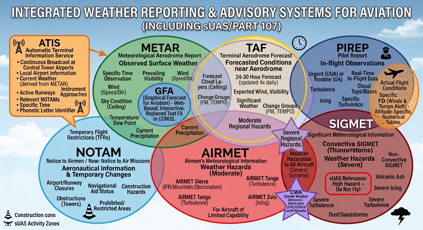
Thunderstorm Stages — UMD
Cumulus · Mature · Dissipating
UMD
U
Cumulus stage — Updraft only
Storm building; rising air feeds moisture upward
M
Mature stage — Mixed drafts (up & down)
Most dangerous — lightning, hail, heavy precip, wind shear
D
Dissipating stage — Downdraft only
Storm dying; downdraft cuts off moisture supply
Exam tip: The Mature stage is the most hazardous — it has both updrafts and downdrafts simultaneously, creating extreme turbulence and wind shear. Never fly near a thunderstorm in any stage.
Chart & Publication Update Cycles
Know what's current before you fly
Chart Supplement (A/FD)
Every 56 days · 8× per year
VFR Sectional Aeronautical Charts
Every 6 months · 2× per year
VFR Terminal Area Charts (TACs)
Every 6 months · 2× per year
IFR En Route Low/High Altitude Charts
Every 56 days · 8× per year
NOTAMs
Continuous — always check before flight
Memory hook: 56 days = the supplement and IFR charts. 6 months = the big sectional maps you carry in the field. The more detailed the chart, the more often it needs updating.
Special Use Airspace — MCPRAWN 🦐
Areas where activities must be confined or aircraft face restrictions
McPrawn
M
Military Operations Area (MOA)
Intense military flight training — VFR allowed but use caution
C
Controlled Firing Area (CFA)
Activities stop when aircraft approach — NOT on sectional charts
P
Prohibited Area
Flight absolutely prohibited (e.g., P-56 over the White House)
R
Restricted Area
Hazardous activities — entry requires ATC permission when active
A
Alert Area
High volume of pilot training or unusual activity — all pilots share equally
W
Warning Area
Hazardous operations off US coasts — no entry permission needed, but avoid
N
National Security Area (NSA)
Sensitive national security sites — voluntary avoidance requested
Exam tip: CFAs are the only Special Use Airspace type not shown on sectional charts because operations cease automatically when an aircraft is detected approaching. Every other type appears on the chart.
Other Airspace Areas — PLUM-TAT
Not Classes A–G, not Special Use — these are the "other" designations
PLUM — TAT
P
Parachute Jump Aircraft Operations
Depicted on charts with a parachute symbol
L
Local Airport Advisory (LAA)
Alaska only — FSS provides advisories at non-towered airports on CTAF
U
Published VFR Routes
VFR Flyways, Corridors, and Class B Transition Routes — help navigate Under complex terminal airspace
M
Military Training Routes (MTR)
IR and VR routes — depicted as gray lines on sectionals
T
Temporary Flight Restrictions (TFR)
Always check NOTAMs — TFRs are not on printed charts
A
Airport Advisory Services (LAA & RAA)
LAA = Alaska only; RAA = Remote Airport Advisory, also Alaska — both provide weather and traffic advisories
T
Terminal Radar Service Area (TRSA)
Participation recommended but not mandatory (unlike Class C)
ADIZ removed: The Air Defense Identification Zone is defined under 14 CFR Part 99 and is not classified as an Other Airspace Area — it's a separate regulatory framework for airspace entry into the US.
TRSA vs Class C: Both use radar separation — but TRSA participation is voluntary. Class C participation is mandatory. If asked on the exam, Class C is the law; TRSA is the suggestion.
Density Altitude — The 3 H's (+ Pressure)
High density altitude = thin air = degraded performance
| Factor |
High Condition |
Effect on Air Density |
Density Altitude |
Performance |
| Heat (Temperature) |
High Temp |
Lower air density |
↑ High |
↓ Reduced |
| Height (Elevation) |
High Elevation |
Lower air density |
↑ High |
↓ Reduced |
| Humidity |
High Humidity |
Lower air density |
↑ High |
↓ Reduced |
| Pressure |
High Barometric Pressure |
Higher air density |
↓ Low |
↑ Improved |
The 3 H's kill performance: Hot + High + Humid = thin air, less lift, less thrust, longer takeoff roll.
Pressure is the exception — high pressure is the good guy. Hot summer day in Denver = worst case scenario.
Quick Formula
Density Altitude = Pressure Altitude + (120 × [OAT − ISA Temp])
ISA standard temp = 15°C at sea level, decreasing 2°C per 1,000 ft
IMSAFE — Personal Minimums Checklist
Self-assess before every flight. One "no" = ground yourself.
IMSAFE
I
Illness
Any symptoms that could impair judgment or reaction?
M
Medication
Any drugs (Rx or OTC) with impairing side effects?
S
Stress
Mental/emotional stress that could distract from the operation?
A
Alcohol
8 hours bottle-to-throttle; 0.04% BAC limit under Part 107
F
Fatigue
Well rested? Fatigue degrades decision-making and attention
E
Emotion
Anger, grief, or excitement that affects focus?
Part 107 — Key Operational Limits
Quick facts — know these cold
Max altitude (standard)
400 ft AGL
Max altitude near a structure
400 ft above the structure
Max groundspeed
100 mph / 87 knots
Max takeoff weight
55 lbs (including payload)
Minimum flight visibility
3 statute miles
Cloud clearance (Class G <10,000 ft MSL)
500 ft below · 1,000 ft above · 2,000 ft horizontal
Daylight operations
Official sunrise to sunset
Civil twilight operations
Anti-collision lights required (visible 3 SM)
Visual line of sight
Unaided eye required (glasses/contacts OK)
Remote ID
Required (broadcast or network)
Waiver-able limits: Many Part 107 restrictions (BVLOS, night without twilight provision, Class B/C/D/E airspace, moving vehicles) can be waived by the FAA with a demonstration of equivalent safety.